News brief from Friday, 20 November 2026 (weather):

For visitors and residents planning outdoor activities in Crete, the useful takeaway is the mix of conditions in the forecast: a cooler spell was expected after a notably warm day, with rain and thunderstorms also possible in parts of Greece at the start of the following week. The forecast does not specify when or where on Crete any rain would occur.
On 20 November, the island recorded the country’s highest reported readings, according to Cretalive’s account of data from the National Observatory of Athens weather-station network. By 16:40, stations in Alikianos (Αλικιανός), in the Chania regional unit, and Sisi (Σίσι), in the Lasithi regional unit, had each registered 29.8°C. Cretalive reported that seven of Greece’s eight highest readings were on Crete.
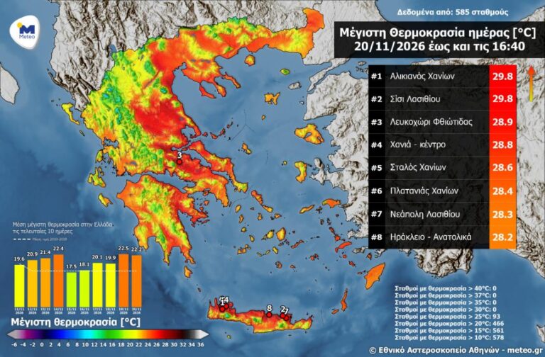
Creta24 also noted mild temperatures elsewhere on the island, including in the regional units of Chania, Lasithi and Heraklion. For Saturday and Sunday, meteorologist Klearchos Marousakis, as cited by Creta24 and Fonien, expected generally good conditions alongside a fall in temperature. His outlook also mentioned northwesterly winds and lower humidity.
A system approaching from the northern Balkans was expected to bring a further change around the start of the next week, with rain and thunderstorms mainly in western and northwestern parts of Greece. The forecast also pointed to southerly winds and rising humidity during the week, while the possibility of Saharan dust remained open. These were broad national projections, not a precise local forecast for Crete.
What does this mean for visitors or expats?
As a practical precaution, check the local forecast before setting out and keep plans adaptable, particularly for outdoor trips. The high reading at two stations does not mean that the same temperature will prevail across the island or throughout a stay.