Today, Saturday, 28 June 2025, red alert in Crete due to strong winds and high temperatures.
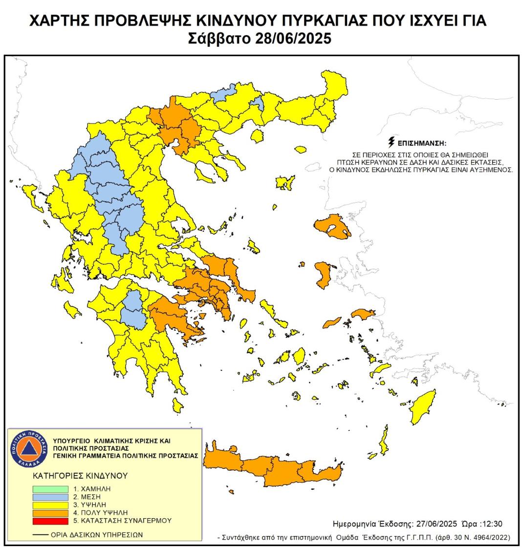
Crete is currently under Red Code mobilisation because of strong winds combined with high temperatures.
These weather conditions significantly raise the risk of wildfires across the island, putting the region in a state of heightened alert.
The entire civil protection system, including the fire department and regional services, has been activated.
Personnel and equipment are being fully deployed to respond quickly to any fires that may start. Honestly, it feels like a tense waiting game.
This is essential for limiting damage and ensuring public safety.
Fire Risk Category and Precautions
Crete is classified at fire risk level 4, which means a very high danger of fire outbreaks.
This rating demands strict measures to prevent fires caused by negligence or accidents.
Authorities have prohibited:
- Burning of crop residues or plant waste
- Smoking near beehives
- Performing hot work such as welding or using cutting tools
- Use of outdoor barbecues or grills
- Launching sky lanterns or any airborne fire sources
- Use of fireworks or pyrotechnics
These bans apply especially in high-risk forest areas, protected natural zones (NATURA sites), parks, and other ecologically sensitive regions.
Restricted Access to High-Risk Areas
To reduce fire hazards, the movement of people and vehicles is limited or banned in vulnerable forest ecosystems and protected green zones.
This helps lower the chances of accidental fires and enables fire services to monitor and protect these zones more effectively.
Region |
Endangered areas |
|---|---|
Azilakodasos Forest, Vathi, Kalo Chorio, Kyparissodasos Kritsa, Krousta Forest (Agios Nikolaos), Thripti, Meseleroi, Selakano (Ierapetra), Vai (Sitia; only between 10 p.m. and 6 a.m.) |
|
Efligia municipal forest, Prof. Ilias, Agios Ioannis, reforestation area south of Arkadi Monastery, Paradisos-Armeni Gorge (Rethymno), Kissos Forest, Agouseliana, Ag. Ioannou, south of the Kourtaliotis springs, Kourtaliotis river to Lake Preveli (Agios Vassilos), Margarita gorge (Mylopotamos), gorge of Agios Antonios Patsos (Amari) |
|
European hiking trail E4 Balos, Falasarna (Kissamos), European hiking trail E4 Krios-Elafonisi and Sougia-Gyaliskari (Kantanos Selino), European hiking trail E4 Sougia-Agia Roumeli (Kantanos), Selino & Sfakia Windmill Park (Kathiana), Prevantorio-Pefka and Agios Matthaios Suburban Forest (Chania), Agios Ioannis-Dasos and Korfos Forest (Gavdos) |
Increased Preparedness and Prevention
The regional protection authorities stress that prevention and self-protection remain critical. Residents and visitors are urged to:
- Avoid any fire use in risk zones
- Report suspicious smoke or flames immediately to the fire brigade
- Follow official instructions during this period of elevated risk
Fire services have also implemented short-term recovery and support plans to help communities affected by potential fires.
Role of the Fire Brigade and Regional Authority
The Fire Brigade works closely with the Region of Crete to manage resources and respond rapidly.
They conduct constant surveillance, prepare firefighting equipment, and coordinate with local officials to reduce the impact of wildfires.
They remind everyone that carelessness remains one of the main causes of fires.
It’s vital to remain alert and responsible during this period of very high fire danger.
Drones Monitor Arson Suspects
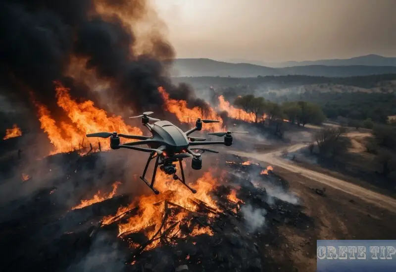
In southern Rethymno, drones have become a crucial tool in the fight against wildfires.
Authorities are using these unmanned aerial vehicles to closely watch areas prone to fire, especially during the high-risk summer months.
The use of drones helps spot fires early and monitor suspicious activity that could lead to arson.
The local municipality has noted that areas like Agios Vasileios suffer significant damage annually from fires, destroying large amounts of land and infrastructure.
This has raised urgent calls for better preventive measures and quicker response times.
Current Surveillance Efforts
-
Ministry Drones: The Ministry of Climate Crisis and Civil Protection has deployed drones to patrol fire-prone zones.
These drones conduct regular flights, recording detailed images and videos to detect smoke or unusual behaviour immediately.
-
Municipal Drone Acquisition: The local government is preparing to acquire its own drone soon.
This will enhance their monitoring capacity by increasing coverage and improving reaction times to potential threats.
Benefits of Drone Monitoring
- Real-time Observation: Drones provide live visual data, allowing authorities to respond quickly to emerging fires or suspicious actions.
- Remote Access: Difficult terrain can be monitored without putting personnel at risk.
- Deterrence: Knowing that drones patrol the skies discourages potential arsonists.
Official Warning
Municipal leaders have issued a clear message to those considering starting fires intentionally.
They underline that any such activities are being recorded and monitored using drone technology.
Authorities emphasise that the increased surveillance will help identify and prosecute arson suspects more efficiently.
This use of drones represents a step forward in protecting vulnerable regions from wildfire disasters, combining advanced technology with local governance efforts.
Frequently Asked Questions
Important information about Fires
– Current Fire Map
– Current fire risk map
Warning apps of the Greek Civil Defense:
– on GooglePlay for Android devices: CivilCrete Talos
– in the AppStore for Apple devices: CivilCrete Τάλως
Fire brigade telephone number in Greece: 199
European emergency number: 112

What are the main factors leading to large-scale wildfires?
Wildfires often start due to natural causes like lightning or human activities such as unattended campfires, discarded cigarettes, or deliberate arson.
Dry weather, high temperatures, and strong winds increase the risk and spread of fires. Vegetation type and land management also influence how quickly a fire can grow.
How can local populations best get ready for unexpected fire outbreaks?
Communities should create emergency plans, including evacuation routes and communication systems.
Clearing dry brush and maintaining defensible space around homes reduces fire risk. Public education on fire safety and readiness ensures people know how to react if a fire occurs.
Regular updates from authorities help residents stay informed.
What immediate steps should be taken if an uncontrolled fire is spotted?
The first action is to alert emergency services quickly.
If safe, try to inform neighbours and help evacuate vulnerable people. Avoid approaching or trying to put out large fires without proper training.
Following official advice and leaving the area promptly can prevent injury.
What role do disaster response teams play during a fire emergency?
Disaster teams coordinate firefighting efforts, manage evacuations, and provide medical aid.
They assess fire behaviour and deploy resources strategically.
These teams also communicate risks and updates to the public and work with local authorities to maintain safety and order.
What methods are most effective for controlling and extinguishing fires?
Common techniques include water and foam spraying from ground crews and aircraft.
Creating firebreaks by clearing vegetation stops flames from spreading. Controlled burns reduce fuel ahead of major fires.
Using specialised equipment and trained personnel ensures better control of large fires.
How is recovery handled in areas heavily damaged by fire?
Restoration usually kicks off with a careful look at how much the soil and plants have been hit. Replanting native trees and plants can really help curb erosion and give the ecosystem a fighting chance to bounce back.
There’s also the not-so-glamorous work: picking up debris and fixing damaged infrastructure. It’s a process that takes time, and honestly, long-term monitoring is crucial—there’s just no shortcut to figuring out what the land and the community need next.

